9 Alternatives to the Blue Ridge Parkway
Would you like to save this full guide?
The Blue Ridge Parkway has an almost mystical pull, with its misty ridges, endless overlooks, and that sense of floating above the world. It’s no wonder millions of people make it their go-to drive each year. In fact, it’s the second most visited National Park Service property, with 2024 seeing 16.7 million vehicles.
However, if you only keep your eyes on that famed road through the Blue Ridge Mountains, you’re missing more magical road trip sights near the Smokies. Whether you’re going to add on to the Blue Ridge Parkway adventure or are looking for more hidden gems, we’re going to help you map out the best alternatives to the Blue Ridge Parkway in the Great Smoky Mountains region.

What’s So Special About the Blue Ridge Parkway?
The Blue Ridge Parkway was built as a scenic experience rather than a way to move traffic quickly between towns. The northern terminus is at Shenandoah National Park in Virginia, with the southern terminus being the Cherokee entrance to Great Smoky Mountains National Park. That’s nearly 470 miles of travel between the two.
As a National Parkway, there are a few things to note:
- Limited access points: You can only enter and exit at specific spots.
- All nature: There aren’t gas stations, restaurants, or hotels on the Blue Ridge Parkway. Just stops at natural spots or NPS amenities.
- Slow by design: Since the goal is to experience nature, the speed limit never goes above 45 miles an hour.
- Preservation > plowing: During winter storms or other weather disruptions, crews on the Blue Ridge Parkway focus on protecting the land first. Local, state, and federal roads, by contrast, have strict requirements to reopen as quickly as possible.
That said, sometimes the alternatives to the Blue Ridge Parkway are by necessity, and not just choice. No matter which road you choose, you’re going to love the views along the way, whether you’re looking for wildlife, waterfalls, or winding mountain views.

Newfound Gap
State: Tennessee & North Carolina
Length: 31 miles (Gatlinburg, TN to Cherokee, NC)
Cutting north/south across Great Smoky Mountains National Park, Newfound Gap Road connects Gatlinburg, Tennessee, with Cherokee, North Carolina. At just over 5,000 feet, the gap is the lowest drivable pass through the Smokies, but it still delivers big views.
The drive covers about 31 miles of curves, overlooks, and trailheads, including the Appalachian Trail. On a clear day, you can see for miles into both states.
NOTE: Newfound Gap is also US 441. Winter weather can close sections, but as a federal highway, it’s cleared and reopened faster than the Blue Ridge Parkway.
Foothills Parkway
State: Tennessee
Length: 72 miles total planned; 33 miles currently open in two main sections.
Tennessee’s consolation prize for being bypassed by the Blue Ridge Parkway is the Foothills Parkway, approved by Congress in 1944. The road was meant to trace the northern edge of the Smokies, but construction has been slow, and only two main sections exist today.
Foothills Parkway East runs 17 miles from Cosby to I-40 near English Mountain, while Foothills Parkway West covers 33 miles from Chilhowee Lake to Wears Valley. Both offer sweeping views of the Tennessee Valley and Smokies.
Moonshiner 28
State: North Carolina, South Carolina, Georgia
Length: ~103 miles (Deals Gap, NC to Walhalla, SC)
Moonshiner 28 is a 100-plus-mile route that crosses into multiple states, but the stretch closest to the Smokies is the real highlight. The name comes from its past as a bootlegging route, once used by moonshiners who ran liquor through the mountains.
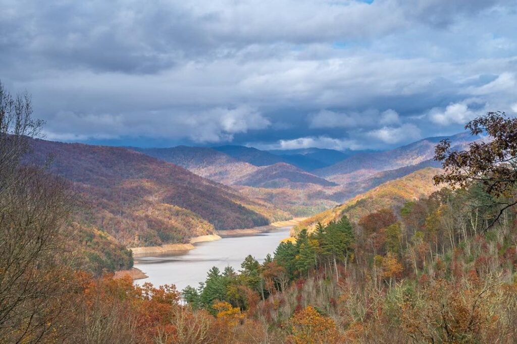
Starting at Deals Gap, where the Tail of the Dragon ends, it winds along Fontana Lake and across Fontana Dam before dropping toward Franklin, North Carolina. It’s worth noting that this 56-mile section from Deals Gap to Franklin is also the Fontana Byway. The Moonshiner 28 goes on to reach Walhalla, South Carolina, if you want to drive that far.

Tail of the Dragon
State: Tennessee & North Carolina
Length: 11 miles (Deals Gap to Tabcat Creek Bridge)
Tail of the Dragon is legendary for its 318 curves packed into just 11 miles along US 129. Hugging the Tennessee–North Carolina border, it’s a favorite for bikers and sports car drivers looking for a road that feels more like a rollercoaster than a highway.
The scenery isn’t as expansive as the Blue Ridge Parkway, but the thrill factor makes it one of the most talked-about drives in the region. It’s safe enough if you respect the curves. There’s also a pull-out at the state lines where you can stand in two places at once.
Cherahola Skyway
State: Tennessee & North Carolina
Length: 43 miles (Tellico Plains, TN to Robbinsville, NC)
The Cherohala Skyway runs 43 miles between Robbinsville, North Carolina, and Tellico Plains, Tennessee, climbing 5,400 feet as it crosses the Unaka Mountains. That’s why it’s nicknamed the “Mile High Legend.”
Built decades after the Blue Ridge Parkway, it delivers a similar mix of sweeping curves and big views but with far fewer crowds. Plus, you’ll get to see portions of the Cherokee and Nantahala National Forests.

Indian Lakes Scenic Byway
State: North Carolina
Length: 75 miles (loop through Nantahala Forest, Fontana & Santeetlah Lakes)
The Indian Lakes Scenic Byway covers about 75 miles in western North Carolina, looping through the Nantahala National Forest. The drive takes you along Fontana and Santeetlah Lakes, across Fontana Dam, and through towns like Robbinsville and Stecoah.
It’s less polished than the Blue Ridge Parkway, but that’s the appeal. You get a mix of mountain curves, lake views, and a glimpse of everyday life in the Smokies.
Nantahala Byway
State: North Carolina
Length: 47 miles (from Marble through Nantahala Gorge to Bryson City)
The Nantahala Byway runs about 43 miles through western North Carolina, starting in the Nantahala Gorge and stretching toward the town of Whittier near Cherokee. The gorge itself is a must-see, with towering rock walls, the Nantahala River roaring beside the road, and rafters and kayakers carving through whitewater.
Past the gorge, the byway winds through small towns and valleys, giving you a mix of adrenaline, scenery, and mountain calm. Even if you’ve seen this route on a Great Smoky Mountain Railroad tour, it’s also an amazing experience from the road.

Waterfall Byway
State: North Carolina
Length: 98 miles (Rosman to Murphy, hugging US 64 with waterfall access)
You’ll go chasing waterfalls through nearly 100 miles of North Carolina forest, and the effort pays off. Most waterfalls, including the famous Bridal Veil Falls, are right off the road. Others make a nice hike to stretch those legs.
This is a great option if your travel includes coming to or from South Carolina/Georgia, since it’s not too far from the state lines. You’ll definitely be far away from the crowds of the Smokies and the Blue Ridge Parkway.
Appalachian Medley
State: North Carolina
Length: 45 miles (Pisgah National Forest near Pisgah to Hot Springs along NC 209)
Tow the line between the Smokies and Blue Ridge Mountains while exploring small towns on the 45-mile-long Appalachian Medley Scenic Byway. As a bonus, you’ll skip Asheville traffic on the route.
What makes the Appalachian Medley Scenic Byway special is that it feels like several scenic drives packed into one. Running along NC 209 between Lake Junaluska and Hot Springs, it blends farmland, forest, and mountain switchbacks into one drive.
You’ll see rolling valleys dotted with barns, then climb into tight curves that bikers love, and finally drop into Hot Springs, a town that lives up to its name.
Shorter Scenic Drive Alternatives to the Blue Ridge Parkway
Not every scenic drive option in the Smokies goes on for miles. Some of the best-kept secrets are tucked in forest foods or above stunning valleys.
- Cades Cove Loop Road – An 11-mile one-way loop through a historic valley filled with wildlife, old cabins, and big mountain views.
- Balsam Mountain Road (Heintooga–Balsam) – A mix of paved and gravel driving, with overlooks above 5,000 feet and a back-door drop into Cherokee.
- Cataloochee Valley – A remote road into one of the park’s quietest corners, known for elk herds and historic buildings.
- Rich Mountain Road – A gravel, one-way escape route out of Cades Cove that winds 7 miles to Townsend with great ridge views.
- Roaring Fork Motor Nature Trail – A 6-mile loop that packs in waterfalls, old-growth forest, and log cabins in one quick trip.
- Kuwohi (formerly Clingmans Dome) – A 7-mile spur off Newfound Gap Road that climbs to the highest peak in the Smokies, ending with a short walk to the iconic observation tower and sweeping 360-degree views.
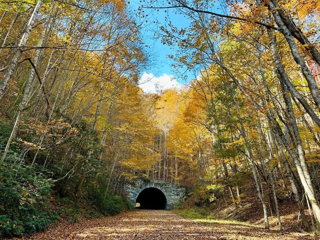
- Road to Nowhere – A six-mile drive from Bryson City that ends at an abandoned tunnel, offering lake views, quiet forest, and a quirky, unfinished history.
Ready for a Great Smoky Mountains Road Trip?
Scenic doesn’t always mean simple. Weather, rockslides, and fallen trees can shut down sections of these routes without warning, especially on the North Carolina side, where higher elevations see more winter weather.
Before you set out, check current conditions. The NPS app is a solid tool for real-time park updates, and state DOT resources will give you road alerts beyond park boundaries. A quick check can stop a scenic drive from turning into a long detour.