A Scenic Adventure Awaits: The ULTIMATE Guide to Exploring the Blue Ridge Parkway
Would you like to save this full guide?
The Blue Ridge Parkway reigns as America’s Favorite Drive and the most visited National Park Service site. In 2023, nearly 17 million people rode this mountainous ribbon of roadway connecting Shenandoah National Park and Great Smoky Mountains National Park.
Across nearly 470 miles, visitors experience the ridgeline and valleys of the Blue Ridge Mountains. Some of the best hikes on the highest peaks and most dynamic waterfalls in the East beg to be explored.
This is like no other road, and that comes with specific guidance we’ve wrapped up into one simple Blue Ridge Parkway planning guide.
NOTE: This guide was written and published prior to the catastrophic flooding due to Hurricane Helene in September 2024.
While parts of the BRP have reopened, the western end is still significantly damaged. Please visit https://www.nps.gov/blri/planyourvisit/conditions.htm for the most up-to-date open/closure information.
What Is the Blue Ridge Parkway?
The Blue Ridge Parkway is the longest of its kind in the country, with an additional pedigree of being an all-American Road due to the stunning beauty of the Blue Ridge Mountains.
While the route goes through many communities, you won’t find gas stations, billboards, or restaurants directly on the Parkway. Up to 1,000 feet of land on both sides of the road are preserved to protect the natural landscape.
Keep in mind that in the 1930s, when the parkway projects were proposed, automobile travel was just becoming a thing. We didn’t even have the interstate system yet!
You might not even realize how every stone, tree, flower, or sign is intentionally designed to enhance your experience driving the Blue Ridge Parkway. This could not be a regular highway — only there to get from Point A to Point B. It had to live up to the excellence of the national park roads.
The definition of a parkway was set in 1936.
A strip of public land devoted to recreation, which features a pleasure-vehicle road through its entire length, on which occupancy and commercial development are excluded, and over which abutting property has no right of light, air, or access.”
– Recreational Committee of the National Resources Committee, 1936
Navigating the Blue Ridge Parkway
The Blue Ridge Parkway’s northern terminus is at Rockfish Gap, Virginia, at the entrance to Shenandoah National Park. Across 469 miles, there are 41 access points – 16 in Virginia and 25 in North Carolina. No entrance fees are charged to drive the Parkway.
The Parkway reaches the southern terminus in Cherokee, North Carolina, just outside Great Smoky Mountains National Park.
That said, there are a few key things to know when driving the Blue Ridge Parkway.
- Do not trust your GPS on the Blue Ridge Parkway. Download the Blue Ridge Pkwy Travel Planner app or get a free map from the Blue Ridge Parkway Association.
- Avoid using Google Maps to navigate the Blue Ridge Parkway. That system will only take you the fastest route, and that’s never going to be the Parkway.
- Before you plan a trip and then when you’re on the road, always check the road conditions and closures. Construction, accidents, and inclement weather can lead to certain sections shut down.
- The road is two lanes and winding, leaving little room to pass slower vehicles. If you are the slower driver, briefly pull over at the next overlook to let faster cars pass.
Mileposts of the Blue Ridge Parkway
The amenities, trailheads, and overlooks of the Blue Ridge Parkway are listed by milepost, which start at 0 at the northern end and work their way south.
The posts aren’t traditional green, reflective highway signs. You’ll be looking for short concrete posts with stacked numbers on the side of the road. Heading south, the posts are on the right. Heading north, the signs are on the left.
Virginia is home to the first 217 miles, with the rest going through North Carolina to Milepost 469 near the Oconoluftee Visitor’s Center in Great Smoky Mountains National Park.
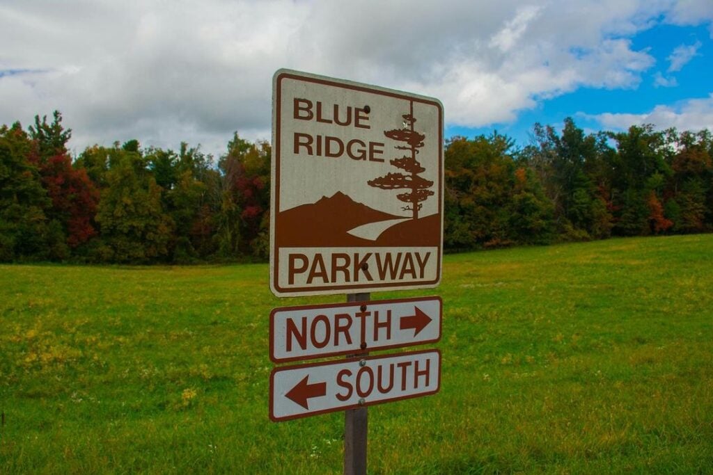
TRAVEL TIP: An easy well to tell if you’re on the Blue Ridge Parkway is by the color of the signs. All distance signs and access points are brown. If you’re on a road with green signs, that’s a local, state, or federal road.
Access Points of the Parkway
Specific locations are designated as access points, which means you can only exit or enter the Blue Ridge Parkway at those locations. Access points can be anywhere from three to 30 miles apart.
If you miss an exit, look for scenic overlooks or other attractions along the way where you can turn around. Use this interactive map as a resource when reading this article and while traveling.
Blue Ridge Parkway Fast Facts
- Length: 469 miles
- Lowest Point: 649 feet at the James River in Virginia
- Highest Point: 6,053 feet at Richland Balsam
- Construction Started: 1935
- Construction Completed: 1987
- Number of Tunnels: 26
- Visitors in 2023: 16,757,635
- Economic Benefit: $1.7 billion and 17,824 jobs in 2022
The Blue Ridge Parkway is the most visited National Park Service (NPS) site in a list of more than 430.
It connects to the Great Smoky Mountains National Park, the nation’s most visited national park, which had 13.3 million visitors in 2023. Shenandoah National Park saw nearly 1.6 million visitors that same year.
The busiest months on the Parkway are September and October, with 2.2 million in 2023. January is the least visited month and also one of the most likely times of year for winter weather closures.
The access point at milepost 388.7 outside of Asheville is the most used entrance.
Must-See Stops on the Blue Ridge Parkway
What are the must-see places on the Blue Ridge Parkway? We get asked this question a lot, and the answer largely depends on what you want out of the experience. Let’s break this question down by interest level.
Scenic Views
Since the road was designed for a leisurely scenic drive, let’s talk about scenic spots on the Blue Ridge Parkway.
It’s important to know that with 272 overlooks, there’s a great view almost every half mile.
The route from Cherokee to Asheville takes about three hours, covering 87 miles. From the Smokies, I would recommend taking it at least as far as Blowing Rock since you’ll cover Mount Mitchell (the highest mountain in the East) and Linville Gorge (the “Grand Canyon of the East”).
That’s about six hours (with minimal stops) and 176 miles one way through the highest elevations of the Parkway.
Perhaps the most famous view is the sweeping curve at Linn Cove Viaduct (milepost 304.4). This was also the last section of the roadway completed. It sits in the shadow of Grandfather Mountain.
The highest visitor center on the Parkway is at Waterrock Knob (5,820 feet/milepost 451.2).
If you’re taking the scenic route from Cherokee, stop at the Museum of the Cherokee People to learn about the culture and legends. That will make the stop at Devil’s Courthouse (milepost 422.4) that much more intriguing when you learn about the legend of Judaculla.
Some of the best views in Virginia on the Blue Ridge Parkway are Mabry Mill, Peaks of Otter, Rocky Knob, and Apple Orchard Mountain.
If you want to give the kids a laugh, plan to stop at the Rough Butt Overlook at milepost 425.4. The word “butt” refers to the sharp dropoff on one side – allegedly.
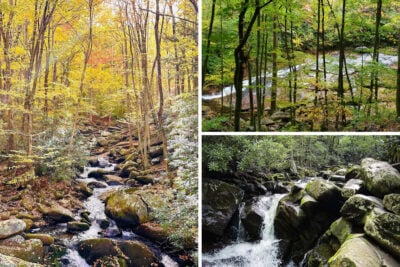
Waterfalls
Pull up Google Maps and search for Transylvania County, North Carolina. That perimeter marks a country known as the Land of Waterfalls, and some are right off the Blue Ridge Parkway or just a short hike away.
The full list of waterfalls on the Blue Ridge Parkway is extensive, but you’ll get plenty of options near the Smokies. The Graveyard Fields Loop Trail has 3.2 easy hiking miles and two waterfalls. Also, put Looking Glass Falls, Crabtree Falls, and Linville Falls on your must-see waterfall list.
NOTE: Skinny Dip Falls was once a popular swimming hole, but a flood in 2021 gutted the land. A smaller version of the falls is still there, but many photos online are outdated and misrepresent what you’ll see now. The hike is still worth it, especially if you get a photo with the Dragon Tree.

Peak Bagging
A bonus of peak bagging on the Blue Ridge Parkway is that no mountain is taller than 7,000 feet, greatly reducing the risk of altitude sickness.
Mount Mitchell is the highest peak in the east, standing 6,684 feet above sea level. It’s at milepost 355.4 on the Parkway and offers a large parking area, a museum, and 40 miles of hiking trails. You will travel five miles off the parkway to Mount Mitchell State Park (no entrance fee!).
It is just 40 feet higher than Kuwohi (formerly known as Clingmans Dome) in Great Smoky Mountains National Park. When you add in the viewing platforms at each peak, Kuwohi (formerly known as Clingmans Dome) actually sits just two feet below the view from Mount Mitchell.
DID YOU KNOW? Elisha Mitchell and Thomas Clingman both believed “their” mountain was the tallest east of the Mississippi. Mitchell went back to his mountain to confirm his findings in 1857. He died after slipping from the top of a waterfall. It would be 25 years before Mitchell was proven right.
Richland Balsam (milepost 431) is the highest spot on the Blue Ridge Parkway, with a moderate 1.3-mile lollipop trail taking you to the summit 6,410 feet above sea level. The scenic overlook is at 6,053 feet.
A Blue Ridge Parkway fan favorite is Grandfather Mountain, with an elevation of 5,946 feet. It gets a little confusing here because Grandfather Mountain is a state park, an attraction, and a mountain. You can hike to the summit without paying, but you will not have access to the Mile High Swinging Bridge and nature center attractions. Let’s make it easy for you:
The highest peak on the Blue Ridge Parkway in Virginia is Apple Orchard Mountain (3,950 feet) at milepost 78.
Mount Pisgah’s 5,721-foot elevation makes it a great place to stop and enjoy a break from the summer heat and humidity. Plus, wildflowers explode with color in the summer. This was once the escape for the rich and famous, including the Vanderbilt family, who built a summer home.
Best Hikes
Hikes for all skill levels and ages are readily accessible off the Blue Ridge Parkway. You can even catch up with a portion of the Appalachian Trail along the way, with the closest sections in Virginia.
Here’s a roundup of your options:
It’s important to note that the Blue Ridge Parkway goes through Nantahala National Forest, Pisgah National Forest, and George Washington and Jefferson National Forests, with access to even more hiking trails.
Unless you’re hiking to peaks, many of the trails start descending, meaning you’ll have the hardest trek of the trail on the way up. Be sure to save water and energy for the way back. Always expect to get your feet wet with the numerous water crossings.
History/Culture
While not every access point has a visitor’s center, museum, or nature center, you still get a fair share of experiences along the way.
Three of the top cultural demonstration stops are Humpback Mountain Farm at milepost 6, Mabry Mill at milepost 176, and the Brinegar Cabin at milepost 238.5.
Those who love stately homes from the past can’t miss the Moses and Bertha Cone summer home at milepost 294. The whole family would love to get their hand on the exhibits at the Museum of North Carolina Minerals (milepost 331). Also, don’t miss the Folk Art Center at milepost 382, with a celebration of all things Appalachian.
To enjoy the sounds of Appalachia mountain life, head to milepost 213 and explore the Blue Ridge Music Center.
While the Blue Ridge Parkway is all about scenery, you won’t want to miss the exciting and sometimes salty stories behind its inception. Here’s one of my favorites.

The Politics of the Blue Ridge Parkway
The concept of the Blue Ridge Parkway seemed easy enough in the 1930s – build a road between Shenandoah National Park and Great Smoky Mountains National Park.
Virginia’s economy would reap the rewards regardless since Shenandoah is just in that one state. As for the other 270 miles, the path to the Great Smoky Mountains put North Carolina and Tennessee at odds.
North Carolina’s Blue Ridge Parkway Argument
The New Deal Era gave hope during the Great Depression. Asheville, a mountain resort town that attracted the likes of the Vanderbilts in the Roaring 20s, was now over its head in debt. Eight banks failed in one day. The Blue Ridge Parkway was the great white hope.
North Carolina, in its argument for the Blue Ridge Parkway, pointed out that Tennessee already had the main entrance to the park in Gatlinburg. They proposed a single North Carolina route that would encompass Mount Mitchell, the highest peak in the east, and showcase stunning mountain scenery that their northern neighbor couldn’t offer.
Tennessee’s Blue Ridge Parkway Argument
The Volunteer State was the Goliath of this story, having most leaders and influencers sold on a three-state parkway that cut west from one of two spots in North Carolina. Fair is fair, right? The trifecta of states would all benefit.
Leaders there argued that cutting through the North Carolina mountains would leave unsightly scars on the wilderness while increasing the costs of building in such rugged terrain. Plus, the weather is better in all seasons – leaving less risk of snow closures.
As with the original David vs. Goliath story, the underdog won, and North Carolina secured the route it first proposed through Asheville.
Don’t feel bad for Tennessee – the ire of state leaders led to the creation of the Foothills Parkway. The Natchez Trace Parkways’ northern terminus is in Nashville. Plus, Tennessee benefited greatly from the Tennessee Valley Authority’s creation.


The Best Time to Visit the Blue Ridge Parkway
Fall is the most popular time to visit the Parkway, as the leaves change between mid-September and late October. The higher elevations will turn first.
However, don’t rule out other times of the year. Summer brings brilliant wildflowers. Spring means robust waterfalls. Even a dreary winter day on the Blue Ridge Parkway means more expansive views since the leaves are off the trees. That said, the Virginia section is at a lower elevation and less likely to be closed due to winter weather than the North Carolina Highlands section.
There is no wrong way to take the Blue Ridge Parkway, and you can easily drive to a section as a day trip or make a two-week vacation out of it. You’ll quickly find out why it’s America’s Favorite Drive.